Sunday, October 13, 2024

An Impulse Adventure on Whiteface Mt.


Yesterday afternoon at 2:38 pm I decided to drive up the Memorial Highway on Whiteface Mountain. I had thought I would wait until today or tomorrow (Indigenous Peoples Day) but the forecast for both days in that area was for rain and the Highway closes for the season after tomorrow. The gate closes at 4:45 so I took the shortest route through Bloomindale and Franklin Falls. There was a line to go through the gate and I got to the gate at 4:40, one of the last allowed up. 

I was also one of the last to come back down because I stopped to photograph the sunset at the Lake Placid turn. The temperature at the summit was 36° F with a fairly stiff wind. I should have had a better coat and gloves but I didn't stay long enough to get chilled. The lines to ride the elevator were ridiculous so I hiked both ways from the parking lot to the summit.

I shot this phone photo on the way down. The rest were shot with my Olympus OM-D E-M5 III and 14-150mm lens, the same kit that I broke on my last trip up Whiteface. It survived unscathed this time (see the July 19 post).

All these photos were made at the Lake Placid turn, the next-to-last hairpin turn going up. The ones above and below were made on the way up.


This is one of only 3 shots on the summit. The cold was bitter and there were mobs of people so I abandoned the summit after a few minutes.

On the way back down I pulled over before the LP turn because there were already several cars parked along the turn and people watching the sunset. Across from where I parked the light from the setting sun highlighted the grass in contrast with the rock.

Lake Plaid in shadow as the sun sets (below).

I shot this with some trepidation. I thought that shooting straight into the sun might create massive flares but the camera handled it and even defined the sun's disk. I did have to do quite a bit of post-shoot editing in Lightroom. I shoot everything in RAW so I had enough dynamic range to pull out the level of detail I wanted.

This one also required post-shoot editing to create the separation of the receding mountains and to cut the digital noise in the foreground.


The last photo (above) required the most editing using both Lightroom and Photoshop. It is my favorite from this mini-adventure. I think I need to get out early or late more. Between getting older and Covid I have been photographing mostly in mid-day for several years now. 

I hope you enjoy the photos of my adventure. I do sell prints (hint, hint). If you are interested contact me. I encourage sharing of the URL to my blog and also of my Zenfolio site, jimbullard.zenfolio.com, but ask that you respect my copyright and do not repost any of my work without permission.

Tuesday, September 03, 2024

Infrared on the 'in town' Rail Trail - Saranac Lake


I wanted to get one last cone at Donnelly's before they closed for the year and decided as long as I was going there I would walk the section of the rail trail between the Rt. 86 parking area on the south side of town and the RR station. You see the world differently at 2 mph than 10-15 mph. For one thing, I noted that there was an unimproved footpath that paralleled the paved rail trail, a remnant of when the train was running, and still used by some for walking dogs (pavement gets too hot for paws) or just for shade.

I had my infrared-converted camera with me and although I took photos with my regular camera which I posted on FaceBook, I ended up shooting mostly IR. The photo below is a 2 frame, stitched image. I liked the light coming through the woods an highlighting the lilypads. 


This is another stitched image that is a 'fail'. I include it as a reminder to those of us who like doing stitched panoramas to pay attention to changes in the light between frames. The passing cloud shadows were more than the stitching software could even out,

On one of my prior trips, another trail user commented that this is the "most serene" cemetery they had ever seen. It is a nice one.

Another stitched photo below, 2 frames one above the other. The surprisingly non-smelly porta-potties just out of the photo on the right and background clutter on the left made the composition a bit difficult but this image is my favorite from the outing.

I liked the reflections on the glass, the curtains, and the window beyond.


For this one, I pressed the lens against the glass which limited the composition options but it still worked out nicely IMO.

I tried the same with another window that had curtains with swirly embroidery but this window had a storm sash on it. The gap between the storm sash and the inner glass resulted in a reflection of my shadow and the trees behind me. Mysterious!


This A-frame wooden bridge fascinates me. On some future outing, I have to explore it further.

I saw two deer on that outing, one on the college campus and the other on a lawn near one of the street crossings. On my ride back from Floodwood (prior post) I saw a pine martin run across the trail. 

Enjoy and share by sharing the link to this page. The photos are copyrighted.


Tuesday, August 27, 2024

Riding the New Section of Rail Trail from Saranac Lake to Floodwood Road.


 On Sunday, August 25, I rode the new section of the Rail Trail from the Saranac Lake RR Station to FLoodwoood Rd. It was not officially open until the following day but lots of walkers and bikers were already using it, especially the SL end. There were far fewer on the Floodwood end. I like this section better than the SL to LP section (see my prior post) partly because there were fewer people but mainly because it is so much wilder and more scenic. My bike's odometer measured the distance from the RR Station to Floodwood at 16.3 miles making this a 32.6 mile round trip. I spent over 2½ hours doing the round trip but I stopped a lot for photos.

The causeway across Lake Colby. There are rest spots 'bumped out' along the sides for sitting, fishing or whatever.


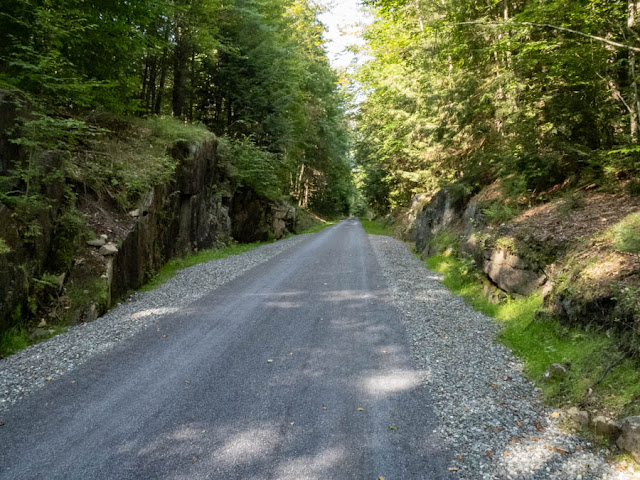
This entire section has a hard-packed fine crushed stone surface.


There are numerous pull-offs where you can rest without blocking the trail or even have a picnic.


Friday, August 09, 2024

Riding the Saranac Lake to Lake Placid rail trail


On Wednesday I took my new ebike to the new rail trail between Saranac Lake and Lake Placid, NY. The currently open trail is 10.25 miles from its intersection with Rt. 86 on the North side of SL to the old train station in LP.  I took my Olympus TG-6 for the photos in this post and started at the parking area on the South side of town.

There is parking on both sides of Rt. 86 at that point and both are paved but the trail South from there to LP is fine gravel over a firmly packed surface. I did not shoot any photos going to LP. What grades there are easy and I am pretty sure I could have ridden it with an ordinary bike although I still need to get in better riding shape. I hadn't ridden in over two years before getting the ebike only a couple of weeks ago so I may be overestimating my ability to do 20+ miles unassisted.

At the LP end the parking area needs work. It isn't paved and is pretty rough. The fat tires on my bike handled it but I wouldn't like to ride a narrow tired bike across it. Although I was not aware of it going to LP it is about 250' higher than SL so much of the trail is a long gradual uphill. There is a low point between them so the total elevation change was 889' for both directions combined according to my tracking app. On my return trip, I turned the pedal assist off for around 2/3rds of the way because it was downhill. I had only used the lowest level of assist going to LP.

All the following photos were taken on the return trip. If you click on them, you will get a larger version.


My bike at one of the bridges.

Wild Morning Glory AKA Bindweed.


Beaver dam with Jewelweed.


When I arrived back at the parking area I asked another biker if the part on the other side of Rt. 86 was also open and he said it was so I rode that section as well. It is all paved between the South and North crossings of Rt. 86, about two miles, and IMO has the best scenery. There are several road crossings on this section.

The view in this spot was the best, so much so that I shot it from a different angle on the return trip.

The old RR buildings (below) are not currently being used but there is another paved parking area there that could be a good starting point if you are coming from the North.


The currently completed sections end by BluSeed Art Center but reports say that the next section will be completed this fall, perhaps even later in the month (August 2024). That section will include the causeway across Lake Colby. I think I will go back when the autumn leaves are out


Above is the other angle on the view I mentioned above. I can see the trail becoming popular with plein air artists as well as walkers and bikers.